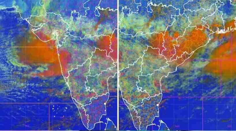
NEW DELHI: India’s active southwest monsoon has entered a powerful phase, with satellite imagery released by the Indian Space Research Organisation (ISRO) revealing two massive weather systems simultaneously bringing intense rainfall to Maharashtra on the west coast and West Bengal in the east. The remarkable images highlight the scale and intensity of the ongoing monsoon activity, which has triggered heavy rain alerts across several parts of the country.
The satellite observations provide meteorologists with a clearer understanding of how multiple atmospheric systems are interacting over the Indian subcontinent. These weather patterns have contributed to widespread rainfall, raising concerns over flooding, waterlogging, transport disruptions, and possible landslides in vulnerable regions.
Twin Rain Systems Visible from Space
According to ISRO, the satellite imagery captured two extensive cloud formations developing over different parts of India at the same time. One of the systems was concentrated over Maharashtra and adjoining regions along the western coast, while another powerful rain-bearing system was spread across eastern India, particularly over West Bengal.

The images demonstrate the vast extent of moisture-laden clouds feeding these systems and underline the complexity of the current monsoon circulation. Weather experts say such observations from space play a critical role in tracking storm development, rainfall intensity, and the movement of cloud bands in real time.
Active Monsoon Driving Heavy Rainfall
Meteorological agencies have attributed the ongoing weather to an active southwest monsoon, supported by favourable atmospheric conditions over the Arabian Sea and the Bay of Bengal. The simultaneous strengthening of weather systems on both coasts has resulted in widespread precipitation across several states.
Maharashtra has witnessed persistent heavy showers, with parts of Mumbai and surrounding districts experiencing waterlogging and disruptions to daily life. In eastern India, West Bengal has also recorded significant rainfall, prompting authorities to remain on alert for possible flooding in low-lying areas.
The India Meteorological Department (IMD) has forecast that active monsoon conditions are likely to continue, with heavy to extremely heavy rainfall expected over several regions in western, central, and eastern India during the coming days.
Also Read: Sri Ganganagar Horror: A Child’s Cries Must Not Be Ignored
Importance of Satellite Monitoring
Satellite-based weather monitoring has become an essential tool for forecasting severe weather events. By continuously observing cloud formation, atmospheric moisture, and storm movement, satellites help scientists improve rainfall predictions and issue timely warnings.
The latest imagery released by ISRO demonstrates how advanced Earth-observation technology supports disaster preparedness. Such observations allow meteorologists to monitor evolving weather systems over oceans and land, helping authorities prepare for heavy rainfall, flash floods, and related emergencies before they escalate.
Accurate satellite data also assists aviation, agriculture, water resource management, and emergency response agencies by providing near real-time information about weather developments.
Impact on Public Life
Heavy rainfall associated with the twin monsoon systems has affected transportation and normal life in several regions. Waterlogged roads, traffic congestion, and localised flooding have been reported from multiple districts experiencing intense downpours.
Authorities in vulnerable areas have advised residents to remain cautious, particularly in flood-prone zones and hilly regions susceptible to landslides. Disaster management teams remain on standby as weather officials continue monitoring rainfall patterns.
Farmers, meanwhile, are closely watching the progress of the monsoon, as sustained rainfall is crucial for the ongoing kharif cropping season. While adequate rainfall supports agriculture, excessive precipitation over short periods can damage crops and affect rural infrastructure.
Scientific Insight into India’s Monsoon
The satellite images also provide valuable scientific insight into the behaviour of India’s complex monsoon system. Weather over the Indian subcontinent is influenced by multiple interacting atmospheric circulations, pressure systems, ocean temperatures, and moisture transport from both the Arabian Sea and the Bay of Bengal.
When these systems become simultaneously active, they can produce extensive cloud cover and intense rainfall over geographically distant regions at the same time, as seen in the latest observations over Maharashtra and West Bengal.
Scientists continue to analyse such satellite data to improve weather forecasting models, helping enhance early warning systems and reduce the impact of extreme weather events.
With the monsoon expected to remain active over the coming days, authorities are urging citizens to stay updated with official weather advisories and exercise caution in areas likely to experience heavy rainfall and flooding.
Click here to join us on WhatsApp Channel and get all the latest news updates